Tracking concluded
News Helicopters Converging
Near over UCLA
This tracking record has ended. A ground outcome was not confirmed in this update.

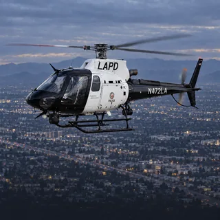
As of 3:45am: nothing overhead. Latest: 2:26am — LAPD (N472LA) circled for 5 minutes, low. Live view ↓
Helicopter activity, local stories, and recent flights. Los Angeles County.
Tracking covers an approximate 2.2-mile radius around Sawtelle, including nearby areas. This is not the West LA Sawtelle Neighborhood Council boundary. The council area runs from Wilshire to I-10 and from I-405 to the Santa Monica city boundary / Centinela, excluding federal VA property. GTLA is an independent tracking service.
Sawtelle, Los Angeles County
As of 3:45am: nothing overhead. Latest: 2:26am — LAPD (N472LA) circled for 5 minutes, low.
GTLA Live · Live area briefing · positions from ADS-B, rechecked every 20 seconds
The aircraft recorded here most often across the full recorded history.
Find it next time in Your neighborhoods.
Saved only in this browser. No account or notifications.
Choose alerts for unusual helicopter activity over Sawtelle, not routine passes.
Choose alertsSaving does not turn on alerts.
Nothing overhead now. The last helicopter left 75 minutes ago, heading east.
Verbs like “held over” and “circled” describe the recorded flight path, not what was happening on the ground. Nothing here states a crime, a fire or a casualty.
Who flies over Sawtelle
9 recorded passes by private and charter helicopters over Sawtelle, 0.3 hours overhead in total.
Private and charter aircraft are usually in transit, on a tour or a survey flight, and pass through without stopping.
Save this page, choose alerts, or add a Home Screen shortcut.
Save & alert settings ↑Measured airspace record
GTLA Live has recorded 18 helicopter passes over Sawtelle, Los Angeles County across 6 days of tracking — 24.4 passes per week (0.8 hours overhead per week), most often Private / civil.
Latest recorded update:
Every aircraft our tracking has recorded here recently, most recent first. The named ones have a page of their own.
What it usually means
Private / civil: Private and civil helicopters are usually in transit, on a charter, or on a survey flight.
Police (LAPD / municipal): Police helicopters typically orbit for a search, a pursuit, or to support officers on the ground. A tight circle overhead usually means the activity is directly below.
News helicopter: News helicopters usually mean live coverage of a developing story — a pursuit, a fire, or a scene the station is broadcasting.
Nearby coverage
Most helicopter activity over Sawtelle is one of four things: police aircraft supporting officers on the ground, news helicopters covering a developing story, fire or air-medical aircraft responding to an emergency, or private and military aircraft simply transiting the area. This page shows which one is overhead right now, identified by operator.
Police aircraft usually fly tight, repeated orbits over one spot and often stay for a long time. News helicopters tend to hold a wider circle at a higher altitude and arrive after an incident is already underway. This page labels each aircraft by its operator, so you don't have to guess.
GTLA Live tracks public ADS-B and MLAT broadcasts that aircraft transmit about their own position, the same open data used by air-traffic enthusiasts worldwide. It is updated every few seconds.
More from GTLA
From the aircraft overhead to the story on your block.
Follow real aircraft in 3D or 2D. See their identities, distinctive fleet liveries, flight trails, and the airspace around them—including temporary flight restrictions.
Launch AirWatch →Hear a helicopter? Find the aircraft near your location, see who operates it, and jump straight into tracking it on the map.
Identify an aircraft →Explore helicopter activity by neighborhood: what’s overhead now, recent visits, and the aircraft that keep coming back. Follow the places you care about.
Find your neighborhood →Revisit concluded scenes with 3D flight-track playback and archived station video when available. Open a Film Room replay from the Incident Desk’s briefing log.
Browse stories & replays →Bring local TV or radio alongside the live map. Follow the aircraft while you watch available station coverage, all inside AirWatch.
Open AirWatch · choose TV or Radio →Choose alerts for police chases and breaking scenes, or every news helicopter launch. Turn on the neighborhood you’re in with one tap, any other from its own page, and manage it all in one place.
Choose my alerts →Run a local website? Put a live Sawtelle helicopter badge on it →