
Helicopters over Norco
Live helicopter tracking for Norco, Riverside County — updated every few seconds.
Saved on this device. No account needed. Alerts are a separate choice.
Live airspace over Norco
Expand live map →Norco, Riverside County
Checking the sky overhead…
GTLA Live · Live area briefing · positions from ADS-B, rechecked every 20 seconds
Keep up with Norco
Saving the page and turning on alerts are separate choices. Choose alerts below, or keep a shortcut for your next visit.
Today over Norco
Nothing overhead now — quiet for the last 4 hours.
- 12:29pm — Orchard Lane (N222DM) passed through in 2 minutes, mid-level.came from Corona (12:29pm)went on to Eastvale (12:32pm)
- 10:56am — November Alpha (N556SH) passed through in 3 minutes, mid-level.came from Corona (10:56am)went on to Mira Loma (10:59am)
- 9:43am — Riverside Sheriff (N996RS) passed through in 3 minutes, mid-level.came from Corona (9:43am)went on to Mira Loma (9:47am)
Verbs like “held over” and “circled” describe the recorded flight path, not what was happening on the ground. Nothing here states a crime, a fire or a casualty.
Familiar aircraft and neighborhood patterns
The sky over Norco
By hour of day
Who flies over Norco
- Private51%
- Police23%
- Sheriff17%
- Military4%
- Fire / rescue2%
- Other2%
The regulars over Norco
The aircraft recorded here most often — the ones you’ll see again.
- Riverside PDN911RP76 recorded visits· last here Mon 10:30 PM
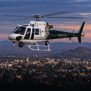 Riverside SheriffN997SD47 recorded visits· last here Mon 9:57 PM
- Private / civilN232PG42 recorded visits
- Orchard LaneN222DM30 recorded visits· usually 11am–2pm· last here Fri 12:32 PM
- Riverside PDN951RP20 recorded visits· last here Tue 11:06 PM
Seen over Norco lately
Every aircraft our tracking has recorded here recently, most recent first. The named ones have a page of their own.
- Orchard LaneN222DM
- November AlphaN556SH
- Riverside SheriffN996RS
- Riverside SheriffN998SD
- Chino PDN710PD
- SkyFOX 11 / SkyCALN93DD
- Riverside PDN951RP
- Mil / CG12-72265
- Riverside PDN911RP
- Mercy AirN908KB
- CHPN985HP
- Ontario PDN50NT
Who flies over Norco, by the numbers
Private and charter helicopters over Norco
369 of 717 recorded passes over Norco were private and charter helicopters — 51% of the traffic here, 15.8 hours overhead in total.
Most often: Orchard Lane (N222DM), 30 recorded passestypically 1,500–2,150 ft
Private and charter aircraft are usually in transit, on a tour or a survey flight, and pass through without stopping.
Police helicopters over Norco
167 of 717 recorded passes over Norco were police helicopters — 23% of the traffic here, 7.2 hours overhead in total.
Most often: Riverside PD (N911RP), 34 recorded passestypically 1,250–1,700 ft
Police aircraft typically fly tight, repeated orbits over one spot to support officers on the ground, and can hold for a long time.
Sheriff's helicopters over Norco
122 of 717 recorded passes over Norco were sheriff's helicopters — 17% of the traffic here, 6.9 hours overhead in total.
Most often: Riverside Sheriff (N996RS), 15 recorded passesusually 9am–12pmtypically 1,150–1,400 ft
Sheriff's aircraft fly patrol, search and rescue across the county, and orbit a scene the same way police aircraft do.
Military helicopters over Norco
28 of 717 recorded passes over Norco were military helicopters — 4% of the traffic here, 0.8 hours overhead in total.
typically 2,000–5,000 ft
Military aircraft are almost always transiting between bases or on training flights; they rarely orbit a neighborhood.
What it usually means
Private / civil: Private and civil helicopters are usually in transit, on a charter, or on a survey flight.
Police (LAPD / municipal): Police helicopters typically orbit for a search, a pursuit, or to support officers on the ground. A tight circle overhead usually means the activity is directly below.
Sheriff (LASD): Sheriff's helicopters typically orbit for a search, a pursuit, or to support deputies on the ground.
Military: Military aircraft are usually transiting between bases or on a training route rather than responding to anything local.
Recent helicopter activity
- Oct 23, 12:29 PMOrchard LaneN222DM · CLON1,600–1,950 ft2 minN
- Oct 23, 10:56 AMNovember AlphaN556SH · R221,475–1,650 ft3 minNE
- Oct 23, 9:43 AMRiverside SheriffN996RS · AS501,025–1,250 ft3 minN
- Oct 22, 7:43 PMRiverside SheriffN998SD · AS501,300–1,425 ft2 minSW
- Oct 22, 2:18 PMChino PDN710PD · B5051,200–1,525 ft8 minNE
- Oct 22, 11:33 AMOrchard LaneN222DM · CLON1,750–2,100 ft2 minN
- Oct 22, 11:01 AMOrchard LaneN222DM · CLON2,125–2,325 ft3 minSE
- Oct 22, 7:01 AMSkyFOX 11 / SkyCALN93DD · B4071,400–1,500 ft2 minSW
Nearby coverage
Questions about helicopters over Norco
Helicopters over Norco common questions
Why is a police helicopter circling over Norco?
Police helicopters account for 23% of the 717 helicopter passes recorded over Norco. The one you see most is Riverside PD (N911RP), 34 recorded passes. They typically fly at 1,250–1,700 ft above sea level. Police aircraft typically fly tight, repeated orbits over one spot to support officers on the ground, and can hold for a long time.
Is that a sheriff's helicopter over Norco?
Sheriff's helicopters account for 17% of the 717 helicopter passes recorded over Norco. The one you see most is Riverside Sheriff (N996RS), 15 recorded passes. They are usually 9am–12pm here. They typically fly at 1,150–1,400 ft above sea level. Sheriff's aircraft fly patrol, search and rescue across the county, and orbit a scene the same way police aircraft do.
How high do helicopters fly over Norco?
From the passes recorded here: private and charter helicopters at 1,500–2,150 ft; police helicopters at 1,250–1,700 ft; sheriff's helicopters at 1,150–1,400 ft; military helicopters at 2,000–5,000 ft. These are the middle half of measured altitudes above sea level for each group, not a floor or a ceiling.
How long do helicopters stay over Norco?
Most passes are brief — a minute or two straight through. The aircraft that stay longest here are private and charter helicopters: 15.8 hours overhead across 369 recorded passes. Private and charter aircraft are usually in transit, on a tour or a survey flight, and pass through without stopping.
How can I tell if it's police or a news helicopter?
Police aircraft usually fly tight, repeated orbits over one spot and often stay for a long time. News helicopters tend to hold a wider circle at a higher altitude and arrive after an incident is already underway. This page labels each aircraft by its operator, so you don't have to guess.
Where does this data come from?
GTLA Live tracks public ADS-B and MLAT broadcasts that aircraft transmit about their own position, the same open data used by air-traffic enthusiasts worldwide. It is updated every few seconds.
More from GTLA
Your way into GTLA.
From the aircraft overhead to the story on your block.
- 01Live aircraft
Know what’s overhead.
Follow real aircraft in 3D or 2D. See their identities, distinctive fleet liveries, flight trails, and the airspace around them—including temporary flight restrictions.
Launch AirWatch → - 02Near you
Who’s hovering here?
Hear a helicopter? Find the aircraft near your location, see who operates it, and jump straight into tracking it on the map.
Identify an aircraft → - 03Your neighborhood
Make it local.
Explore helicopter activity by neighborhood: what’s overhead now, recent visits, and the aircraft that keep coming back. Follow the places you care about.
Find your neighborhood → - 04Film Room
Replay the story.
Revisit concluded scenes with 3D flight-track playback and archived station video when available. Open a Film Room replay from the Incident Desk’s briefing log.
Browse stories & replays → - 05TV & radio
Tune in. Stay above.
Bring local TV or radio alongside the live map. Follow the aircraft while you watch available station coverage, all inside AirWatch.
Open AirWatch · choose TV or Radio → - 06Personal alerts
Catch the moment.
Choose alerts for police chases and breaking scenes, or every news helicopter launch. Turn on the neighborhood you’re in with one tap, any other from its own page, and manage it all in one place.
Choose my alerts →